| The subject of this article is from the SentinelUp update.
The information from this article is up-to-date as of 12 April, 2022. |
The information from this article is up-to-date as of 12 April, 2022.
| This article is about the current version of the iVc Quadrant Map. For the Atlas Rises version, see Archive:IVc Quadrant Map (AR). |
| IVc Quadrant Map | |
|---|---|
| |
| Galaxy | Euclid |
| Type | POI |
| Description | Historical Location |
| Claimed by | iVc Project |
| Contact name | afWngs |
| Platform | PC |
| Updated | SentinelUp |
iVc Alpha Beacon is a guide.
Summary[ | ]
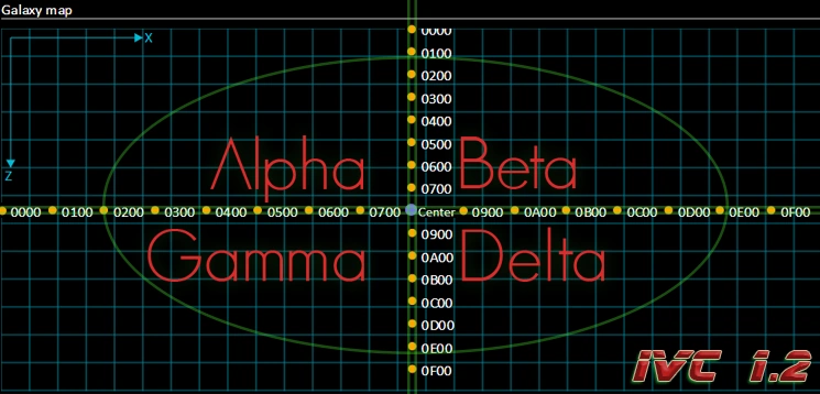
The iVc Quadrant Map is a guide for using the Galactic Map.
The iVc Quadrant Map divides any given NMS galaxy into four major divisions or Quadrants, with lines spreading in each direction (up, down, left, right) from the centre of the galaxy. The Galaxy Centre itself and coordinates very close to it, are regarded as not being in any quadrant.
The map was created by the iVc Project.
Historical Intention[ | ]
In the Pathfinder era, the InterGalactic Voyage Corridor developed a galactic map overlay using and named it the IVc Quadrant Map, which soon became standardized for all travellers, and is now known as Quadrants. In the Pathfinder era, a concept to assign specific beacon systems was developed to aid in galactic map navigation when using Hyperdrive travel. Since the relaxation of Portal interference, this type of travel for long distance exploration is long since obsolete.
The iVc Beacon / Quadrant system was inspired by Star Trek, sci-fi, and aviation navigational concepts.
Four beacons were defined, explored and named in the Euclid galaxy, one in each quadrant. The travellers could visit the those systems using portals, then they would appear in the travelers Discovery menu screen listing of visited star systems. By assigning them as a waypoint on this screen, it would then be possible to use them as navigation guideline for Hyperdrive travel in the the galactic map by selecting Waypoint for travel (Since the Expeditions era, select Custom).
The four beacons were:
- iVc Alpha Beacon
- iVc Beta Beacon
- iVc Delta Beacon
- iVc Gamma Beacon
Outcomes[ | ]
As a result of the definition of the iVC Quadrant Map, it quickly became standardized amongst all major travelling civilizations in the early Atlas Rises era, notably helped by the adoption of it by the Galactic Hub Project and Coordinate Plotting Apps such as Pilgrim Star Process and No Mans Connect.
Secondly, the development activity of this project led directly to the creation of the Alliance of Galactic Travellers amongst a number of collaborative travellers.
Related Articles[ | ]
AGT Galactic Archive[ | ]
 |
Regions • Systems • Planets/Moons • Creatures • Multi-Tools • Starships • Bases | Discord • Facebook • Reddit • Twitter • YouTube • Instagram |  |